
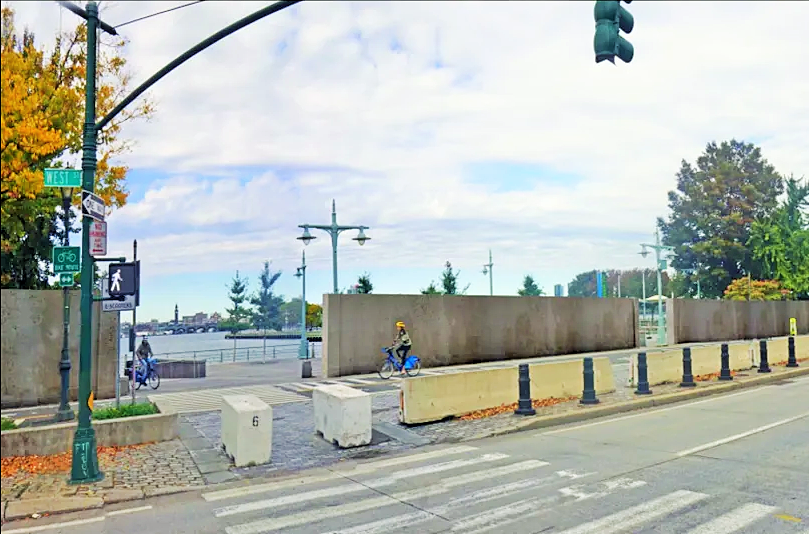
BY TOM FOX | The U.S. Army Corps of Engineers recently released a preliminary flood control plan for Manhattan’s West Side waterfront in Hudson River Park between Battery Park City and W. 34th Street. Their simplistic approach to resiliency is to build a 12-foot-high concrete wall along 3 miles of the waterfront — in the Hudson River Park.
The proposed wall would displace the busiest bike path in America, diminish public use and enjoyment of a $1 billion public park visited by 17 million people a year, impede public access to the river, increase air and noise pollution and block views of the river. It would significantly impact the desirability of the park, undermine the quality of life in adjacent neighborhoods, and erode the value of adjacent real estate and the city’s tax base.
Let’s take a look back at another West Side waterfront project. In 1985, after an 11-year legal battle forced the withdrawal of a U.S. Army Corps Westway permit for an interstate highway buried under 236 acres of landfill in the Hudson River, the governor and mayor established a unique city/state task force. That body brought together agency commissioners and local elected officials, along with community, environmental, business and civic stakeholders to craft a new vision for the West Side waterfront.
Their recommendations were visionary — build a surface-level boulevard and turn the waterfront into a world-class maritime park. The Hudson River Park transformed a dangerous and deteriorating waterfront, preserved the priceless Hudson estuary, made adjacent neighborhoods more livable, increased tourism, created jobs and enhanced the city’s tax base. That progress, and the continued vitality of adjacent West Side neighborhoods, will be undermined by the Army Corps’ current proposal.
In response, the Hudson River Park Advisory Council voted unanimously, on Feb. 13, to request that the governor and mayor establish a new city/state task force to coordinate public infrastructure investments in order to prevent coastal flooding, protect the Hudson River Park, and redesign Route 9A to meet changing transportation needs without impacting traffic congestion.
There are physical, environmental and economic benefits to crafting a new vision that will enable the West Side waterfront to adapt and thrive for the remainder of this century.
The opportunity is unique because three public infrastructure projects could be critical to the future of the park, the estuary and adjacent West Side communities. There has been billions of dollars in public and private investment in the park and in adjacent communities. Coordinating the planning and implementation of major public infrastructure improvements is critical to protecting the benefits that the Hudson River Park has created. Fortunately, new state and federal funding is available to help accomplish these goals.
Start in the estuary
West Side resiliency should include both in-water and shore-based measures. Given that 70 percent of the Hudson River Park is water, mitigating the impact of tidal surges should start in the park’s estuarine sanctuary. Existing natural systems must be preserved as we initiate innovative environmental interventions, such as expanding the current oyster restoration initiative, ecological enhancement of near-shore environments, and wrapping pier piles and surfacing the bulkhead with materials that encourage and support the growth of marine and terrestrial flora and fauna.

The Army Corps regulates all construction in the waterway while the state Department of Environmental Conservation oversees the estuarine sanctuary. In 2018, the governor supported a $135 million estuarine research, restoration and protection plan recommended by the Hudson River Foundation. Roughly $35 million is being spent for new shoreline habitat at Gansevoort Peninsula, ecological improvements at Pier 26, oyster restoration and the design of the estuarium in Tribeca.
Last November, New Yorkers passed a $4.2 billion environmental bond act that can help fund the restoration and protection of the park’s estuarine sanctuary and match any federal funding secured by the Army Corps for coastal protection. However, in-water environmental enhancements won’t succeed without substantially improving water quality. That requires stopping the routine discharge from 33 combined sewer outfalls that dump untreated waste directly into the Hudson River.
Improve water quality
New York City’s combined sewer system mixes raw sewage with stormwater from local streets. Normally, that waste is routed to municipal wastewater treatment plants for processing. But too much water would overwhelm municipal water treatment facilities, so stormwater and untreated household waste is discharged directly into the Hudson during periods of heavy rainfall. The park’s in-water property is designated as an estuarine sanctuary and these discharges wreak havoc on the marine and bird life and create unsanitary conditions for boaters and other park visitors.
A stormwater holding system, like the one installed at Brooklyn’s Paerdegat Basin, could provide a model. There, a city Department of Environmental Protection 48-inch sewer line captures and stores stormwater to prevent its discharge into Jamaica Bay. The sewage is then slowly routed to a wastewater treatment plant after the rain event. The agency issues bonds to build its water treatment facilities and should design and finance this critical type of infrastructure in the Hudson River Park in a comprehensive approach to resiliency.
Redesign Route 9A
Almost 40 years ago, following the demise of the Westway project, the West Side Task Force recommended a surface boulevard to accommodate north-south traffic flow along the West Side corridor and enhance waterfront access for adjacent communities. At that time, the future of the waterfront and the adjacent neighborhoods was unknown, and assumptions were made about what would take place on both sides of the roadway.
Some assumptions were accurate. But few envisioned the dramatic transformation of the Meatpacking District and Hudson Yards, redevelopment of Hudson Square, popular new attractions like the High Line and Little Island, or commercial offices at Pier 57. Back then, the state Department of Transportation’s primary concern was moving traffic along the West Side corridor, and they chose the least expensive roadway alternative. Fast-forward to today and development on both sides of the roadway has matured, both conventional biking and electric-powered micro-mobility have increased exponentially, and congestion pricing is expected to reduce Manhattan vehicular traffic below 60th Street by about 20 percent.
The roadway is fast approaching its planned 50-year lifespan and there have been calls for the city and state to address the roadway’s shortcomings. For example, local community boards, the Hudson River Park Advisory Council and the Manhattan Borough president have requested that one lane of Route 9A be dedicated for electric vehicles used to transport people or goods.
Repurposing Route 9A’s parking lane for micro-mobility would support the current and future use of electric bicycles and scooters, food delivery and small, last-mile package delivery vehicles. That would also enhance bicycle and pedestrian safety in the park. Thankfully, the new $1.2 trillion federal Infrastructure Investment and Jobs Act included $110 billion to improve the nation’s transportation infrastructure and provide the opportunity to meet that need.
Expand the park and use creative shore-based measures
As a public asset, Hudson River Park has created tremendous benefits for the environment, adjacent communities, the city and the region’s economy. Redesigning Route 9A could create an opportunity to expand the park, as well. If the roadway can be narrowed, the park and its bicycle path can be expanded, increasing the opportunity for more creative, and natural, shore-based flood-control measures.
As a West Side Task Force member, I participated in the planning of Route 9A, which was designed to accommodate 1980s traffic levels. The tree-lined, 19-foot-wide median was designed to facilitate pedestrian safety and mitigate air and noise pollution from traffic. Now, the anticipated 20 percent reduction in traffic from congestion pricing argues for a narrower roadway, while new vehicles are trending toward electric propulsion, which is quiet and has no exhaust emissions.
With less traffic, one vehicle lane and the median might be removed from the roadway. That would add 30 feet of width to the Hudson River Park. Except perhaps in the section from 14th to 23rd Streets, where the park is extremely narrow, expanding the park would provide room for creative, shore-based measures, such as 12-foot-high, reinforced landscaped berms to increase park elevations. If the new stormwater interceptor sewer can be integrated in the overall design, city Department of Environmental Protection bond funding could contribute toward shore-based measures and complement federal flood control funding secured by the U.S. Army Corps.
The lack of a U.S. Army Corps flood protection proposal for the northernmost mile of the park between the Javits Convention Center and 59th Street is surprising. Notwithstanding the 20-foot rise in elevation between Route 9A and 11th Avenues, structures lining Route 9A will be vulnerable to future coastal flooding. Several of these structures, such as the Con Edison generating station at W. 59th Street and its electrical substation at W. 49th Street, are critical elements of our power grid. Is there a plan for this area? If not, why not?
I haven’t attempted to illustrate what the future of a West Side waterfront adapted to address climate change might look like. It’s premature to suggest specific designs for a comprehensive approach to these public infrastructure improvements. The task force charged with this mission should be responsible for decision-making with the same meaningful and transparent community participation that led to the creation of the Hudson River Park. Ultimately, all task force recommendations would need to be approved by the governor, mayor and other elected officials.
The U.S. Army Corps’ draconian proposal to enhance resiliency on Manhattan’s West Side should be a catalyst to developing a coordinated effort that will respect natural systems, enhance the public enjoyment of the Hudson River Park and protect the quality of life and tax base in adjacent neighborhoods. It’s time for the city and state to work with key stakeholders from the local, environmental, transportation, civic and business communities to create a new vision to complete the metamorphosis of the West Side into the next century.
Only the governor and mayor can assemble and empower senior level government, civic, business and community leaders to capture this opportunity. No one else can ensure that the Hudson River Park Trust, U.S. Army Corps, city Department of Environmental Protection, state Department of Environmental Conservation, the city and state Transportation Departments and other involved agencies coordinate their efforts.
Taking a comprehensive approach to public infrastructure improvements on the West Side waterfront can prevent coastal flooding, enhance the public use and enjoyment of the Hudson River Park and redesign Route 9A to meet evolving traffic volumes and transportation needs. For others who may be interested in weighing in, the U.S. Army Corps has extended the period for public comments on its proposals to Fri. March 31, at nynjharbor.tribstudy@usace.army.mil.
Excelsior!
Fox was a Westway opponent and the first president of the Hudson River Park Conservancy, which completed the final plan and environmental approval of the park, and represents the City Club of New York on the Hudson River Park Advisory Council. His first-person history of the creation of the park will be published by Rutgers University Press in spring 2024.
Thanks for your counsel and your passion for the river.
A thoughtful article by someone with a long history of advocacy on the West Side Waterfront. Well done, Tom!
Hey Dan,
My apology for mistakenly including you among Westway opponents who vociferously opposed the Park. Mohonk was indeed a major turning point, and the original Friends of Hudson River Park played a critical role in insuring the transformation of the waterfront.
But we disagree on climate change and flood protection. Climate change is a global issue and will not be solved by building large infrastructure projects in New York City. It’s our younger generation’s job to continue what people like you and I have been doing for the last 50 years – treading lightly on the earth. The problems are quickly getting worse and the solutions may be radical.
My background is in biology and ecology, and I think many of our problems with flood protection are the result of poorly planned infrastructure inherited from previous generations that misunderstood the importance of designing with nature. Huge dams in the West allowed millions to live in the desert, which everyone now understands is not sustainable either. It’s beyond my ability to comprehend, or judge, the impacts of the huge physical interventions you propose.
I support a diversified approach to flood protection in differing shoreline situations, including strategic withdrawals from some areas we should never have built on. It’s how you do it that matters, and natural systems should be a primary tool in the process.
Best wishes, Tom
Dear Tom,
Your memory must be failing you. I was there at Mohonk with you (if you were there) and others on the city/state task force “craft[ing] a new vision for the West Side waterfront,” as you put it. Later, with Paul Willen, I developed the concept for Riverside South, a 25-acre extension of Riverside Park to 59th Street, to connect with Hudson River Park (including a modest real estate development). I was even part of Friends of Hudson River Park, at the beginning.
My background is in physics, which encompasses not only air pollution, but also hydrology, if need be. I agree that we should dream big. That’s why I like your idea of a new city/state task force, but why limit it to the West Side? All the waterfronts of the city need a plan for storm surge and for sea level rise. The Corps’ proposal for the region is badly flawed. Many neighborhoods, including the West Side, reject the Corps’ utilitarian concrete walls and wide, grassy levees. (Yes, that is their plan for Chelsea Waterside Park). And many more neighborhoods are left out entirely.
The optimum solution, in my opinion, is a regional storm surge barrier system, such as the ones in London, the Netherlands, Venice and even Stamford, Providence and New Bedford, that would protect the entire region from the kind of storm surge that occurred during Hurricane Sandy. But environmental groups are afraid that, as sea level rises, there would be pressure to use those gates more and more often for other purposes. We need a plan to deal with sea level rise, too, so that the storm surge gates would only be closed for storms. A city/state (actually bi-state) task force to develop a plan for sea level rise is perfect. Thanks for suggesting it.
Hey Dan, Good to hear you’re still kickin’. Dreaming big and following through in a consistent and persistent fashion is what got us the Hudson River Park, which you fought against. When we opposed Westway, you were, and I assume still are, an expert in transportation and air pollution – not hydrology, aquatic environments, and flood control.
Your first point leaves open the possibility that there very well may be a reduction in traffic on Route 9A commensurate with the rest of the city. And it’s you who defined my suggestion of a reinforced landscaped berm as a levy denuded of all vegetation save grass, not me. I’ve been working in parks for the last 40 years and I know what I mean by reinforced landscaped berm – and it’s not a New Orleans levy. Take off your curmudgeon hat and try on a creative one for a change.
This study is the first step in an unfunded project that will begin in 2030 and continue to 2044. Dream big, inspire others, be creative and persistent – stranger things have happened. You were wrong when you opposed the Park 30 years ago and just might be again. Best wishes, Tom.
Nice to see Tom Fox dreaming big again. However, his ideas come with problems.. First, while congestion pricing will reduce traffic overall, there may not be any reduction on Route 9A next to Hudson River Park, according to the MTA’s projections (see MTA Environmental Assessment, Figures 17-7 – 17-9). Second, “12-foot-high, reinforced landscaped berms,” better known as levees, are actually almost 100 feet wide and cannot be landscaped, under Corps of Engineer regulations, except by grass. In particular, trees are banned because their roots could compromise flood protection.
The best bet for Hudson River Park is to preserve what we have. Flood protection for the vast majority of the New York / New Jersey harbor region could be provided by a storm-surge barrier, most likely between Coney Island and Staten Island with a supplemental barrier at Throgs Neck, that would keep flood waters out of New York Harbor.